What was there – historical photos and Google Maps

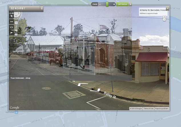
What was there uses historical images and Google Maps to look at how places have changed overtime. You can add photos to specific locations and then using Google Street View, overlay images from the past and present.

what was there 3

A particularly nice feature of the interface is the option to fade between photographs and the street view image. Anyone over 13 can register with the service and add images, tag by location and year, save locations, and position images to overlay with street view.

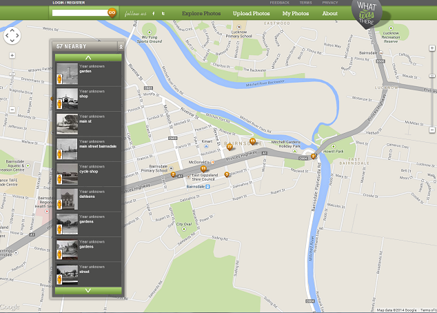
There are some great examples of cities that have thousands of photographs pinned to different locations, including New York which has around 2000 images. Closer to home, the Victorian regional town of Bairnsdale has around 60 historical images pinned to shops and community buildings.

What was there 1

With so many cultural institutions digitising collections and making images freely available online, tools like What Was There give students and teachers the opportunity to connect to local history in new ways. The State Library of Victoria has thousands of out of copyright images of regional towns around Victoria that can be used freely for educational purposes.

Imagine students finding images of their town or suburb’s main street a hundred years ago and comparing it to today? Or even their own house or school? Try searching for your town or suburb name in the SLV catalogue and see what you can find.

Global Education Project

In this guest post Heath Graham (Project Officer for the Geography Teachers’ Association of Victoria) introduces resources and webinars for the Global Education project. 

The Global Education Project is an AusAid-funded initiative, designed to encourage teachers to take a global perspective in the classroom across all learning areas. The Global Education website features teaching activities, videos, image galleries and other resources. Resources cover a range of Global issues including Water & Sanitation.

The Victorian branch of the Global Education Project is hosting a series of webinars on range of global education topics. The first session covers Primary level resources on the topic of water, to coincide with the International Year of Water Cooperation. The second session gives a general introduction and overview of the global learning emphases and their application in the Primary classroom.

Webinar details:

Global Education And The International Year Of Water Cooperation

August 6, 2013 from 3:45pm to 5:15pm Session details

Global Perspectives in the primary classroom: building global citizens

August 7, 2013 from 3:45pm to 5:15pm Session details

These sessions are hosted in Blackboard Collaborate. If you have not used Blackboard before, DEECD have set up a Virtual Conference Centre to help you get started:

http://www.education.vic.gov.au/school/teachers/support/Pages/vcc.aspx

animoto for geography

Penleigh and Essendon Grammar teacher librarian Joanna Durst has created a terrific animoto as a guide for her year 7 geography students.

Joanna explains:

I prepared this one to demonstrate how the Year 7 students might make one for their “My favourite destination” unit in Geography. It was lots of fun.

Screen shot 2010-08-12 at 3.09.01 PM

Creating your own digital story or presentation is an excellent way to show students what can be achieved. Nice work Joanna and thanks for sharing.

Google Earth Outreach Showcase

The Google Earth Outreach Showcase is a terrific way to teach students about how “how non-profit and public benefit organizations are using Google Earth and Maps to visualize their cause. You can see both Earth and Maps projects, and read about the impact the organizations have had using these different mapping technologies.”

Examples include:

  • World water map
  • Clean water in Haiti
  • Southern Forests for the Future
  • Chile earthquake maps

A fantastic resource for geography; fantastic maps with lots of added information for students to make connections with. A reminder that you will need to have Google Earth downloaded on your computer before you can access these maps.

iBoard player

The iBoard player is a terrific interactive teaching resource. With resources for Prep to 2, there is lots of fun and learning to be had.

Resources include:

  • Numeracy
  • Literacy
  • New Literacy (Texts)
  • Science
  • History
  • Geography
  • ICT
  • Religion

A day in the country

This year 1 example above comes with the following information from the website:

Ask pupils to position the characters and construct sentences about their position or movement.
Using the whole scene, you could challenge pupils to make a wider range of statements than those given… “the bird is flying above the girl”, “the owl is on top of the big bear’s head.”
Ask pupils to position the characters and construct sentences about their position or movement. Using the whole scene, you could challenge pupils to make a wider range of statements than those given… “the bird is flying above the girl”, “the owl is on top of the big bear’s head.”
The iBoard player looks like a useful tool for learning for younger students.

World’s biggest earthquakes since 1900 – interactive map

The CNN World website has developed a terrific resource for students researching earthquakes. Showing both the biggest and most deadly earthquakes since 1900, each map has captions for each area showing date, place, magnitude and death toll.

Biggest earthquakes

Biggest earthquakes

Deadliest quakes

Deadliest quakes

Earthquakes are presented by ranking.  A very good resource to begin researching the world’s earthquakes. Thanks again to Richard Byrne from Free Technology for Teachers for informing me about this top tool!

Fotobabble

Recently, The Nerdy Teacher Nick Provenzano posted an article on Fotobabble on his excellent blog.

Further uses include narrated postcards for Geography, commenting on photos for History, quick book reviews, commenting on art works – the uses are endless!

Fotobabbles can be embedded into blogs, wikis and other websites and shortly there will be the option of creating slideshows.

Students can use their own photos or those from copyright free or Creative Commons websites and then record a narration. Fotobabbles may be kept private, just remember to ensure the privacy box is ticked and click ‘save’. As with most social media sites, there is a way of reporting objectionable content, but there is no way of ensuring students don’t find any, unless you investigate first and supervise use.

Using Fotobabble in class could be a good introduction to Creative Commons and the moral and legal use of images.

National Geographic Kids

National Geographic Kids is a fun and educational site by the reputable crew from National Geographic. Featuring kids’ games, activities, animals, photos, videos, stories and more, this site is sure to be a hit with both students and teachers.

National geo kids

The site is choc full of content that is both educational and fun. Lots of geographical information on countries that includes facts, photos, videos, maps and more. Highly recommended!